
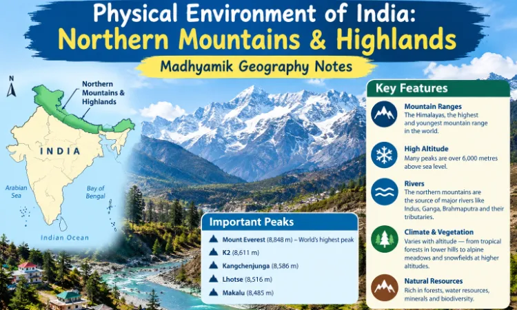
Northern Mountainous Region and North-Eastern Highlands
These notes present the important facts, mountain ranges, peaks, glaciers, passes, valleys and plateaus in simple English for quick revision.
- Northern Mountainous Region
The major mountain ranges of the northern mountainous region include the Karakoram, Ladakh, Zanskar and Himalayas.
The Himalayas are young fold mountains formed mainly due to the collision of the Indian Plate with the Eurasian Plate.
- Karakoram Range
- Location: Northern part of the Indian subcontinent, extending towards the Pamir Knot and Kunlun Mountains.
- Length: Approximately 500 km.
- Highest peak: K2 or Godwin Austen (8,611 m). Highest mountain peak in India.
- K2 is the world's second-highest mountain peak after Mount Everest.
- Important glaciers: Siachen, Baltoro and Hispar.
- Siachen is commonly described as India's longest glacier.
- Other important peaks include Gasherbrum I, Gasherbrum II and Broad Peak.
- Ladakh Range and Plateau
- Ladakh is a high-altitude region characterised by a cold desert climate.
- It receives very little rainfall because it lies in the rain-shadow region of the Himalayas.
- Important lakes: Pangong Tso and Tso Moriri.
- Important region: Aksai Chin.
- The landscape consists of high mountains, barren plateaus and deep valleys.
MCQ focus: Pangong Tso and Tso Moriri are famous lakes of Ladakh.
- Zanskar Range
- Location: South of the Ladakh region.
- The range forms part of the Trans-Himalayan and Greater Himalayan mountain system in regional geographical descriptions.
- Important place: Kargil.
- Important passes associated with the wider Himalayan region include Shipki La, Lipulekh and Mana Pass.
Remember: These passes belong to different Himalayan sectors; they should not all be classified as lying within the Zanskar Range.
- Himalayan Range
- The Himalayas are the highest mountain system in the world.
- They are young fold mountains.
- They extend from the Nanga Parbat region in the west to Namcha Barwa in the east.
- Their length is approximately 2,400–2,500 km.
- Their width varies from about 250 to 400 km.
- The Himalayas influence India's climate, rainfall, rivers, agriculture and natural environment.
Two major classifications of the Himalayas
- Latitudinal division: Trans-Himalaya, Himadri, Himachal and Shiwalik.
- Longitudinal division: Western Himalayas, Central Himalayas and Eastern Himalayas.
- Latitudinal Divisions of the Himalayas
The four major divisions from north to south are as follows.
- Trans-Himalaya
- Located to the north of the main Himalayan ranges, adjoining Tibet.
- Important ranges: Karakoram, Ladakh and Zanskar.
- K2 is located in the Karakoram Range.
- Himadri or Greater Himalayas
- The highest and most continuous major Himalayan range.
- Average elevation is approximately 6,000 m.
- Important peaks: Mount Everest, Kanchenjunga, Makalu, Dhaulagiri and Nanda Devi.
- Contains many important glaciers.
- Himachal or Lesser Himalayas
- Located south of the Himadri.
- Important ranges: Pir Panjal and Dhauladhar.
- Famous valleys: Kashmir, Kullu and Kangra.
- Popular hill stations: Shimla, Manali and Dharamshala.
- Shiwalik or Outer Himalayas
- The southernmost and lowest major Himalayan division.
- Elevation is generally about 600–1,500 m.
- Consists largely of foothill deposits of gravel, sand and other sediments.
- Longitudinal valleys between the Shiwalik and Lesser Himalayas are known as Duns. Example: Dehradun.
Memory trick: North to south — Trans-Himalaya → Himadri → Himachal → Shiwalik.
- Longitudinal Divisions of the Himalayas
- Western Himalayas
The Western Himalayas are commonly divided into three geographical sections.
- Kashmir Himalayas
- Located in Jammu and Kashmir and the Ladakh region.
- The Indus and its tributaries are important rivers.
- Important ranges include Karakoram, Ladakh, Zanskar and Pir Panjal.
- Characterised by glaciers, snow-covered peaks, deep valleys and lakes.
- Himachal Himalayas
- Located mainly in Himachal Pradesh.
- Important ranges: Zanskar, Pir Panjal, Dhauladhar and Shiwalik.
- Famous valleys: Kullu, Kangra, Lahaul and Spiti.
- Important passes: Zojila, Rohtang Pass, Bara-lacha La and Shipki La.
- Important hill stations: Shimla, Manali and Dharamshala.
- Kumaon Himalayas
- Located mainly in Uttarakhand.
- Important peaks: Nanda Devi, Kamet and Trishul.
- Famous lakes: Nainital, Bhimtal and Sattal.
- Important glaciers: Gangotri and Yamunotri.
- Important passes: Mana Pass and Niti Pass.
- Central Himalayas
- The Central Himalayas lie mainly in Nepal.
- In the conventional longitudinal classification, they extend broadly between the Kali River region and the Singalila Range.
- Mount Everest, the world's highest peak, is located in Nepal.
- Eastern Himalayas
- Extend from the Singalila region towards Namcha Barwa in the east.
- Major divisions:
- Darjeeling–Sikkim Himalayas.
- Bhutan Himalayas.
- Arunachal Himalayas.
Darjeeling–Sikkim Himalayas
- Sandakphu is the highest peak in the Darjeeling region.
- Kanchenjunga is the highest peak in India and a prominent mountain of the Sikkim Himalayas.
Bhutan Himalayas
- Located in the mountainous territory of Bhutan.
Arunachal Himalayas
- Located in northeastern India.
- Characterised by high mountains, deep valleys and numerous rivers.
- North-Eastern Highlands or Purvanchal
Purvanchal refers to the group of hills and mountain ranges extending along the India–Myanmar border in northeastern India.
Major hill ranges
- Patkai Bum Hills
- Naga Hills
- Manipur Hills
- Mizo or Lushai Hills
MCQ focus: Purvanchal is located in northeastern India, along the India–Myanmar border region.
- Meghalaya Plateau
- The Meghalaya Plateau is considered an extension of the Peninsular Plateau of India.
- Major hill ranges:
- Garo Hills
- Khasi Hills
- Jaintia Hills
- The Karbi Anglong or Mikir Hills are located in Assam and are associated with the wider northeastern plateau region.
- Cherrapunji and Mawsynram are famous for very heavy rainfall and are located in the Khasi Hills region.
MCQ focus: Garo + Khasi + Jaintia = Major hill ranges of the Meghalaya Plateau.
Important Points at a Glance
|
Question |
Answer |
|
Highest mountain in the world |
Mount Everest |
|
Highest mountain peak in India |
Kanchenjunga |
|
World's second-highest peak |
K2 |
|
K2 is located in |
Karakoram Range |
|
Glacier commonly described as India's longest |
Siachen Glacier |
|
Highest major Himalayan division |
Himadri |
|
Southernmost Himalayan division |
Shiwalik |
|
Example of a Dun valley |
Dehradun |
|
Famous lakes of Ladakh |
Pangong Tso and Tso Moriri |
|
Important river of Kashmir region |
Indus |
|
Nainital and Bhimtal belong to |
Kumaon region |
|
Gangotri and Yamunotri are associated with |
Uttarakhand |
|
Highest peak of the Darjeeling region |
Sandakphu |
|
Hills along the northeastern border |
Purvanchal |
|
Major hills of Meghalaya Plateau |
Garo, Khasi and Jaintia |
Short Answer Questions
- Why are the Himalayas called young fold mountains?
Answer: The Himalayas were formed mainly by the collision of the Indian Plate with the Eurasian Plate. Compression caused the Earth's crust to fold and rise. Geologically, the Himalayas are relatively young mountains.
- Name the four major latitudinal divisions of the Himalayas.
Answer: Trans-Himalaya, Himadri, Himachal and Shiwalik.
- Write two differences between the Himadri and Shiwalik ranges.
Answer:
- Himadri is the highest major Himalayan division, whereas Shiwalik is the lowest and southernmost division.
- Himadri contains high snow-covered peaks and glaciers, whereas Shiwalik consists mainly of lower foothills and sedimentary deposits.
- What is Purvanchal?
Answer: Purvanchal is the group of hill ranges in northeastern India extending along the India–Myanmar border region. It includes the Patkai, Naga, Manipur and Mizo hills.
- What is a Dun valley? Give an example.
Answer: A Dun is a longitudinal valley situated between the Lesser Himalayas and the Shiwalik Range. Dehradun is a well-known example.
- Explain the importance of the Karakoram Range.
Answer: The Karakoram Range contains some of the world's highest mountain peaks, including K2. It also contains important glaciers such as Siachen and Baltoro. The region is significant for its high-altitude landscape and glacial systems.
- Write three features of the Kumaon Himalayas.
Answer: The Kumaon Himalayas are located mainly in Uttarakhand. They include peaks such as Nanda Devi and Kamet. The region is also associated with the Gangotri and Yamunotri glaciers and lakes such as Nainital and Bhimtal.
- Why is the Meghalaya Plateau important?
Answer: The Meghalaya Plateau is an extension of the Peninsular Plateau. Its major hill ranges are the Garo, Khasi and Jaintia Hills. Cherrapunji and Mawsynram, famous for heavy rainfall, are located in the Khasi Hills region.
- Important Corrections for Competitive Exams
- Mount Everest: Its officially recognised height is 8,848.86 m. Older books may mention 8,850 m.
- K2: It lies in the Karakoram Range, in the Pakistan-administered Gilgit-Baltistan region. Kanchenjunga is conventionally listed as India's highest mountain peak.
- Sandakphu: It is the highest peak in the Darjeeling region. Kanchenjunga is the second highest peak in India.
- Mana Pass: Avoid automatically describing it as India's highest pass; rankings vary according to the definition and the passes included.
- Formation of the Himalayas: Their formation took place over a long geological period, rather than through a single earthquake or only three mountain-building movements.